
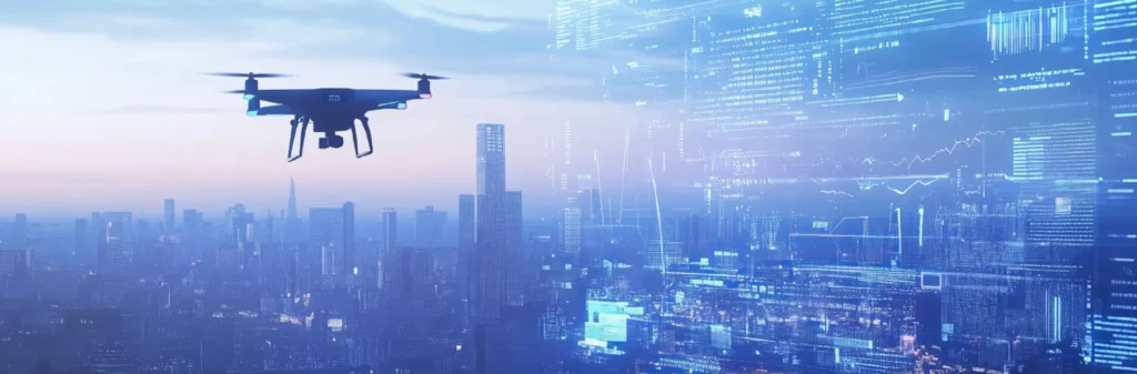
The role of drones
in smart governance
In brief
Drones are beginning to play an increasingly important role in digital governance, not only as flight platforms, but as mobile systems of observation, analysis, and response. Equipped with cameras, sensors, LIDAR, thermal vision, and recognition software, they can capture information from their surroundings, combine it with other data, and help build systems that are more predictive, coordinated, and effective. In China, this logic is already starting to become especially visible.
Introduction
When people talk about digital governance, attention usually falls on data platforms, dashboards, and predictive models; but the quality of those systems depends on the quality of the field data they receive.
Drones are becoming relevant for digital governance not simply because they fly, but because of their ability to provide mobile, on-demand sensing where fixed infrastructure has blind spots. They make it possible to observe, verify, and respond more effectively when integrated into broader management systems.
In China, that logic is already visible in municipal public-safety, infrastructure, and emergency-response deployments.
This article closes the series on the low-altitude economy — which began with the direct experience of flying in Hangzhou and continued with the economic and industrial analysis of the sector — by focusing on one of its most revealing dimensions: how nearby airspace is beginning to be used to see territory more clearly and manage it more effectively.
Smart governance
begins with better percepcion
What a fixed sensor network can already do — and where they stop
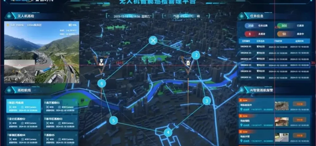
At the heart of any smart governance system lies the ability to perceive the environment. Cameras, meteorological sensors, air quality monitoring systems, flow counters, and monitoring stations installed on lampposts, towers, buildings, and infrastructure form a data collection network that has already reached significant density in many Chinese cities. That fixed network provides continuous and reliable information about what is happening at specific points across the territory.
The problem is that a fixed network sees well where it is located, but it cannot move. When something happens between two cameras, in a place without sensors, or when an anomaly needs to be confirmed from another angle, the fixed network reaches structural limits that cannot be solved simply by adding more stationary points.
Why a mobile aerial layer changes everything?
Adding a mobile aerial layer does not just increase data volume; it closes information gaps and improves confirmation speed.
It changes the system’s capabilities in qualitative terms. A drone can move to the exact point where better visibility is needed, confirm an anomaly, capture a scene, or assess a risk more precisely than any fixed camera.
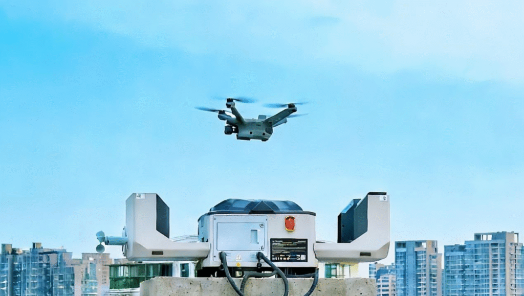
In practice, this model can be implemented through autonomous drone docks or mobile stations that launch, recover, and recharge aircraft with minimal human intervention.
When the system detects something — a weather alert, a traffic accident, a thermal anomaly — the capsule opens, the drone takes off autonomously, performs its mission, and returns to recharge, all without an operator on site.
How do drones help manage a territory?
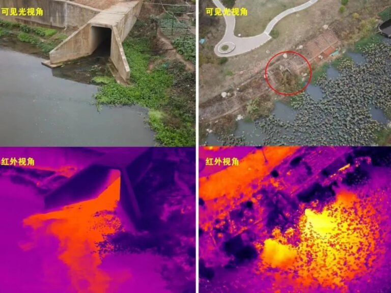
The clearest way to explain it is this: they add mobility to a system that, without them, can only see from fixed points. A drone equipped with optical cameras, thermal sensors, and LiDAR does not just fly. It maps, detects, evaluates, and transmits information in real time. When that information is combined with climate models, territorial databases, or emergency systems, the drone stops being an isolated tool and becomes part of a much broader observation and response network.
Drones as the mobile senses of the system
From flight platform to observation organ
As I discussed in my article on the senses of machines, artificial perception is not an add-on to intelligent systems. It is the layer that makes applied intelligence possible. A system that cannot perceive well cannot interpret well or act well. That same logic applies directly to drones when they evolve from flight platforms into advanced perception platforms.
What makes the drone relevant to governance is not simply that it can fly, but that it can see, map, detect anomalies, and send useful information in real time. Once all of that is integrated, the drone stops being just a vehicle and begins to act as a mobile organ within a distributed sensory architecture.
Why the combination of fixed network and mobile layer is qualitatively different?
This is not about stacking technologies. It is about changing the architecture of the governance system itself. A fixed network plus a mobile aerial layer does not produce twice as much data. It produces a system that can respond sooner, confirm sooner, and anticipate better. The two levels feed one another: the fixed network identifies warning signals, and the drone moves to the point of interest to close the information loop with higher-resolution data.
key idea
In intelligent governance, the drone becomes a mobile platform of perception that expands the system’s ability to see, interpret, and act.
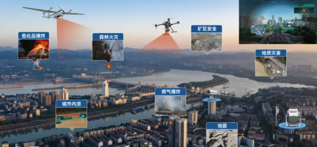
Governance applications already operating in China
Fire prevention and firefighting: from detection to early intervention
One of the clearest examples is forest fire management. In China, drones equipped with thermal sensors and computer vision systems are already patrolling risk zones autonomously. When system parameters — temperature, humidity, wind, and historical conditions — cross certain thresholds, the alert level rises and the drone can be deployed without waiting for manual instructions.
Beyond patrol work, some models are designed to act directly on the fire. They can operate at altitudes above 600 meters, identify hot spots with thermal cameras, and drop extinguishing agents onto them. For facade fires or areas with difficult vertical access, other systems use drones connected to a high-pressure hose anchored on the ground, removing both payload limitations and battery duration constraints.
The operational logic is the same: the system moves before ground observers can fully verify the event. It acts when the indicators suggest one may be forming.
Emergencies, infrastructure inspection, and territorial monitoring
These applications extend across very different contexts, but they all share the same logic of integration. In emergency management, drones can reach difficult-access areas before any ground unit and provide an initial operational assessment: how many people are there, what is the situation, and what resources are needed. In cities like Shenzhen — where a network of more than 200 urban air mobility routes is already being managed — drones mounted on police vehicles can reach accident scenes before officers, evaluate conditions, and help coordinate the traffic response.
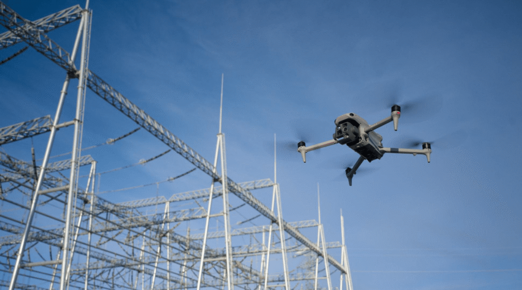
In infrastructure inspection, autonomous drones conduct programmed flights over power lines, dams, gas pipelines, or roads, detecting anomalies that would be costly or dangerous to identify through human inspection. In rural or island areas, they can provide emergency logistics — medical supplies, food, equipment — where other infrastructure is slow or unavailable. For nighttime operations, tethered drones connected to the power grid can illuminate rescue zones from thirty meters up with powerful floodlights, without requiring complex installations.
Can a drone replace a fixed surveillance camera?
Not exactly, because the two play different roles. A fixed camera provides continuous, passive coverage of a specific point. A drone provides active, mobile coverage when needed.
The drone complements fixed infrastructure by moving into blind spots, confirming anomalies, and improving response timing.
The two systems complement each other more than they compete.
Where is this heading: the most revealing dimension
From isolated data to anticipatory judgment
In digital governance, the goal is not to accumulate data. It is to turn scattered signals into operational judgment. If sensors and cameras detect certain conditions — a thermal anomaly, an unusual traffic pattern, risky weather conditions — and that data is crossed with historical models and alert systems, the response can begin to become anticipatory rather than merely reactive. The system does not wait for the problem. It learns to recognize its precursors.
That is where the drone starts to fit into something larger: not only as a response tool, but as part of systems capable of anticipating better and acting earlier.
Territory as a distributed nervous system
The most useful image for understanding where this field is headed is not that of a city full of drones flying overhead. It is the image of a territory with more eyes, more listening capacity, and greater speed of reaction than before: a fixed sensor network combined with a mobile aerial layer, connected to real-time analytics platforms, allowing those who manage infrastructure or emergencies to see more, understand more, and act earlier.
This architecture is not science fiction. As we saw in the analysis of China’s low-altitude deployment model, it is already being built in China with an industrial density and certification speed that Europe has yet to match. But the logic of the system — using nearby airspace as a layer of perception and response — is not exclusively Chinese. It is an evolution that any government or institution dealing with complex territories should understand, and understand deeply.
The drone in the broader context of machines that perceive
This article would be incomplete without pointing to a broader connection. Drones, as we have seen, are systems of mobile perception. That perceptive capacity — cameras, sensors, LiDAR, computer vision — is the same capacity I have explored in other platforms: manufacturing robots, industrial inspection systems, and autonomous vehicles and the senses of machines. The domain changes. The logic does not. Systems that can perceive well are the systems that can act with judgment.
Implications for european governments and institutions
The questions that matter before adopting these technologies
Adopting drones in governance systems is not just a technological decision. It is a decision about institutional architecture: what data is collected, how it is used, who has access to it, under what legal guarantees, and within what oversight frameworks. Those questions are not barriers to adoption. They are the conditions that make adoption meaningful and capable of generating public trust.
In the European context, where the U-Space regulatory framework is still developing and the first coordinated low-altitude traffic demonstrators are beginning to operate, there is room to build a distinctly European model. One that integrates the logic of distributed perception with the standards of transparency and data protection that Europe has turned into a differentiating asset.
The real challenge is not technical. It is organizational. And that, perhaps, is where the comparison with China becomes most instructive: not as a model to imitate, but as evidence of what becomes possible when regulation, industry, and deployment move with coherence and compatible speed.
For European institutions, the key question is not whether drones can be used, but how to define governance, oversight, data access, and interoperability under the U-space framework.
A final idea
Drones are not only expanding what a city, a logistics network, or an infrastructure can see. They are also expanding what those systems can learn, anticipate, and coordinate. When an aerial platform perceives, interprets, and transmits useful information in real time, we are no longer simply dealing with a technical tool. We are dealing with a new layer of the territory’s nervous system.
And perhaps that is one of the keys to the next technological cycle: not so much creating spectacular machines, but building systems capable of perceiving better in order to govern better.
Contact us if you want to learn more about these technologies and the ecosystem that supports them.